There’s something irresistibly enchanting about an old map of Australia. It’s not just lines and faded pen; it’s a passport to the past. The rolled-up edges, yellowed paper, and old-fashioned spots tell a tale that’s half mystery, half adventure. To most history enthusiasts, collectors, and curious minds, that map is not really a geographically-focused snapshot—it’s a portal into how people used to view the world, long before satellite imaging and Google Maps.
Maps created during the 1600s and 1700s tend to be more imagination than fact. Australia, then often called “New Holland,” looked curiously stretched or distorted, placed mysteriously in the unknown extremities of the globe. Mapmakers and early travelers completed the gaps with guesswork, sea monsters, and untamed coastlines. And miraculously, these errors are only part of the maps’ charm.
Table of Contents:
What Early Cartographers Thought Australia Was
When explorers had sextants and sailing ships, they were not blessed with accuracy. They had to deal with sights, rough estimates, and a great deal of artistic license. So if a curious researcher in the modern age comes upon an old map of Australia, they may still find Tasmania clinging to the mainland, or the eastern coast altogether missing.
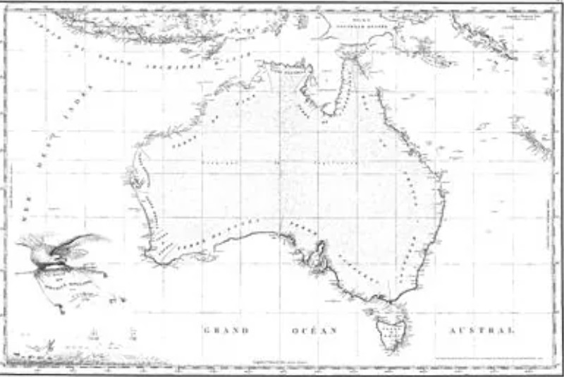
Curiously enough, most of these initial renderings were influenced by the imagination of Europeans. The “Great Southern Land” was believed to counterbalance the landmass in the Northern Hemisphere. The outcome? Maps where Australia was drawn like a puzzle piece of anchorage, nestling amidst whirling winds, treacherous oceans, and the odd sea dragon.
It’s not about cartographical precision so much as the attitude of the era—wondering, speculating, and oftentimes fanciful.
Traces of Adventure in Every Faded Line
Every old map of Australia has a different taste of discovery. One may have Captain Cook’s route drawn in red ink, cutting across the eastern coast. Another is drawn from Dutch explorations, naming points with long-forgotten or rebadged names. Each coast is an inspiration for some fearless human who ventured forth into the unknown with nothing but a compass, the stars, and pure courage.
Both collectors and historians value such maps for the romance they inspire. They are a reminder of an era when the world was larger, when paper blanks were locations of promise or risk—or both. And although contemporary maps are streamlined and functional, they can never hope to match the poetic appeal of old parchment, sketchy drawings, and optimistic annotations.
Why Old Maps Still Capture the Imagination
There is a subtle, abiding excitement in possessing or merely looking at an antique map of Australia. It’s the nearest one may get to time traveling. The ink of the mapmaker may have been dry for centuries, but his or her curiosity can still talk to us today.
Even those with no occupational interest in geography will catch themselves gazing up at one for much longer than they anticipated. Reading a diary penned in symbols and coastlines, there’s enigma in each malformed bay and enchantment in each out-of-proportion island.
Fascination Grows Around Old Map of Australia
Today, the search for an ancient map of Australia goes on in various antique shops, auctions, and dusty libraries. Others lie hidden away in family trunks, waiting to be discovered until someone notices they’ve been sitting on a piece of history. Each map’s idiosyncrasies, its mistakes, and its myths resonate with us. And maybe that’s what makes them so lovable. In the end, they remind us that discovery doesn’t always come from accuracy—it often begins with wonder.